
Our streets are becoming congested, and greater Ashland’s infrastructure is crumbling before us. Nightmares such as the 29th Street massacre and the clogged lanes of 13th Street have left many of us concerned about the stability and functionality of our roads. With revitalization fresh in our minds, several political figures in recent years proposed an idea to reduce Winchester Avenue to two lanes, and outside lanes were replaced with special parking spots. A similar system exists in Huntington around 3rd Avenue’s Pullman Square, boasting a rejuvenating downtown vibrant with local business. Ashland’s implementation of this system is bringing many new possibilities to the downtown area.
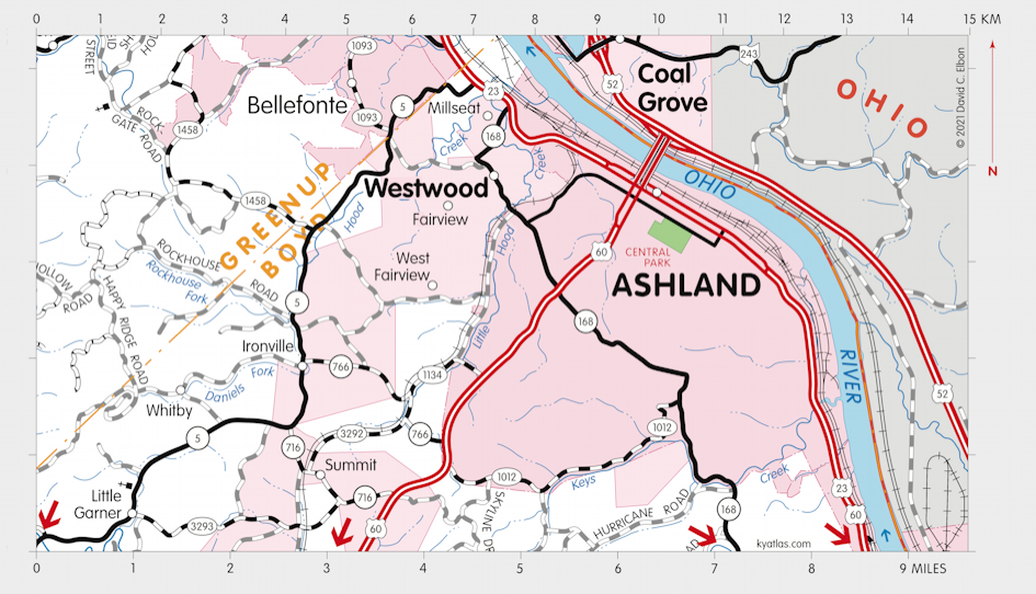
Without an easily accessible freeway, however, downtown Ashland is unable to handle its present and growing volume of traffic. Interstate 64 avoids entering the city limits of Ashland, only providing direct access to Cannonsburg, Catlettsburg, and surrounding communities. US 52 only provides access to Ashland’s busiest intersection. We have two other old highways which have long been purposed as city and residential streets; US 60 and US 23 are comprised of many intersections, traffic stops, and low speed limits that prevent safe and effective high-speed transportation, effectively cutting Ashland off from a modern world of travel.
Enter a hypothetical designation: Kentucky Route 42, also known as the Adena Highway…
The Adena Highway (KY 42)
Beginning in Catlettsburg near its exit on Interstate 64 and ending near KY 693 in Flatwoods, this eleven-mile freeway could generally run parallel to US 23, cutting through unused hillsides and residential areas, and feature a number of interchanges to provide easy access to and from greater Ashland’s busiest spots. This expandable four-lane freeway would have speed limits of 65-70 MPH, no traffic lights or stops, and no intersections, only exit/entrance ramps. I think it’s time for our Commonwealth’s government to invest in a new infrastructure project that could make traveling in Ashland safer, employ struggling workers at home, and totally revitalize our place on the map.
Possible KY 42 interchanges (listed in order from south to north):
1. KY 168: serves downtown Catlettsburg, connecting to U.S. 23 just above the underpass.
2. South Ashland: serves residentials in the south side of Ashland
3. U.S. 60/13th Street: provides direct corridor downtown, as well as a corridor to rural Boyd County
4. Mall Connector Road: provides access to Ashland’s “town center” district
5. KY 693/Diedrich Boulevard: serves growing residentials in Greenup County
Into the Future
Future Interstate planning in Ohio calls for I-73 and I-74 routes from Columbus and Cincinnati, respectively, to Portsmouth, where they will follow current US 52 East through Huntington and then southeast through West Virginia as part of a major corridor from the Great Lakes region to Southern beaches. While it is designated as “Future I-73/74”, West Virginia’s portion of US 52 is far from being upgraded to Interstate standards, and sources say that West Virginia has no plans to upgrade it to meet this status.
If West Virginia won’t take this opportunity, then Kentucky should. With collaboration from the State of Ohio, a new bridge project could carry high-speed traffic from US 52 in Ironton to the hypothetical KY 42, which would connect back with US 23 South by way of I-64 East. US 23 from Catlettsburg to the southern state line of Kentucky would be upgraded to a legitimate freeway, where it would take travelers through the tip of Virginia and into Tennessee, where I-26 currently begins.
This effectively puts Ashland right in the center of a major national corridor stretching from the northern tip of Michigan to the coast of South Carolina.
This is a no-brainer for me. Decongesting downtown’s through-traffic will improve its businesses, and by improving Ashland’s accessibility by citizens from neighboring cities, we will have more visitors spending money in our stores and finding reasons to stay for a while. More accessibility means more opportunity for the people of our communities.
Conclusion
The Adena Highway and the proposed interstate extension are more than infrastructure projects; they represent a vision for a thriving Ashland, ready for growth. These initiatives are not just about roads and bridges; they are about connecting people, creating jobs, and revitalizing our communities.
We urge our elected officials to prioritize these critical infrastructure projects. Contact your state representatives, senators, and the governor. Let them know we need the Adena Highway, the interstate extension, and the revitalization they promise.
Together, let’s pave the way for a brighter future for Ashland—a future where our roads are safe and efficient, where businesses thrive, and where our communities flourish.
It’s time to invest in Ashland.
It’s time to build our future.