
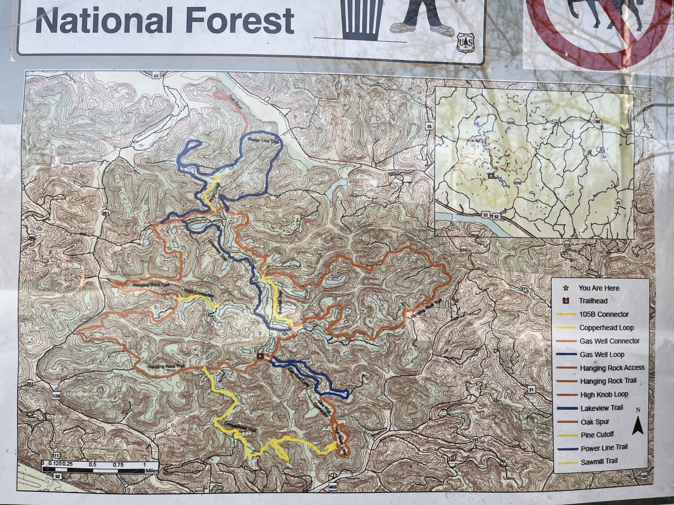
Like Lake Vesuvius, the Hanging Rock OHV System is embedded deep into the woods of Lawrence County, Ohio’s portion of Wayne National Forest. Primarily used for mountain bikes and off-highway vehicles such as four-wheelers and side-by-sides, the Hanging Rock OHV System features 26 miles of multi-purpose trail and over 50 fishing ponds scattered throughout the system. One of these trails is a 2.7 mile multi-purpose trail that is perfect for hiking: the Gas Well Loop.
How to Get to Gas Well Loop
Getting to the trailhead is very easy, though it does require driving out some winding, albeit short, country roads.
If you’re coming from around Portsmouth, then you’ll want to take US 52 East.
If you’re coming from Ashland or Huntington, you’ll want to take US 52 West.
The exit you’re going to look for is the Hanging Rock exit onto Ohio State Route 650. You’ll drive for less than the length of a modern pop song, and on your left you will see the sign for Hanging Rock Recreation Area. You’ll turn left and continue out the twisty roads until you reach the trailhead, which is easily visible upon arrival.
Gas Well Loop
By no means am I an expert on off-road vehicles, so I won’t get too much into the details about the rest of the trail system. I went on the Gas Well Loop trail for just a short hike on a Thursday evening in March, which is out of season for OHVs.
Getting to the Gas Well Loop is a little bit confusing; there are no signs at the trailhead that specifically say Gas Well Loop, so you have to go further into the access trail at the trailhead to actually get to the Gas Well Loop trailhead. Once you get there, it’s pretty easy to make your way along the trail.

I didn’t encounter another soul on the trail itself; I did, however, meet a man at the trailhead who was picking up trash along the side of the road. We had a brief conversation about ticks, and he told me about a man he knows that can no longer eat meat because of a tick bite. As a devoted carnivore, I want to prevent this condition from ever plaguing my body, and that’s why I use a high quality tick spray to repel them from my body. Not only will this spray keep the ticks away, but it’ll keep 55 other types of insects away as well, including mosquitoes, chiggers, and mites.
The trail itself is very well-maintained and well-marked. Since it is primarily used for OHVs, the trail is made of gravel most of the way and is very wide. I’d imagine that in the summer months it might be a little bit hard to hike on the trail, but in the winter and spring it’s a piece of cake.

AllTrails describes the trail as moderately challenging, which I would agree with. The trail has some very steep inclines which are more appropriate for a vehicle with an engine rather than two legs with a significantly weaker engine, but so long as you push through you shouldn’t have any trouble getting through it. Some users on AllTrails consider the trail to be easy. As an intermediate hiker, I can understand both sentiments.
The trail was also very clean for the most part. There were a few moments where I did see some beer cans and a red Solo cup, but other than that it seems to be regularly cleaned. The trail also crosses over with the road at one point, and the last leg of the trail is part of the roadway, so you’ll definitely want to be careful and watch for any traffic. It’s unlikely that you’ll see much traffic other than maybe a few OHVs.

While on the trail I got this really uneasy feeling, and I don’t know why. I thought that maybe it was due to the sun setting and not being familiar with the trail. When I’m on an unfamiliar trail and I don’t know where it ends, I start to get a little bit anxious.
Fortunately, I had AllTrails installed on my phone and I was able to see the map of the full loop and use that to guide my way through. I would highly recommend downloading AllTrails and subscribing to the premium version of the app. With AllTrails premium, you can download offline maps just in case you have no service, you can get notifications every time you make a wrong turn, unlock more map details, and also unlock 3D maps. It’s worth the $3.99/month price tag if you’re on the trails often, and they say that AllTrails+ users are twice as likely to get outside. Use it as motivation!
The Gas Well Loop is an interesting trail, and it might be one worth revisiting shall I ever get an OHV and dive into that lifestyle. If that’s the case, this article will be expanded upon. For now we’ll leave it at this.
Have you been to the Gas Well Loop? What did you think about it?